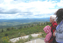
 Situated midway as the crow flies between Saint-Herménégilde and East Hereford, Mount Hereford is tucked away in the extreme southeast corner of the Eastern Townships. At 864 metres (2,835 feet), the summit of Mount Hereford has a panoramic view of the countryside in all directions. The area is sparsely populated and dominated by rolling hills, forests and cultivated river valleys. Coaticook lies a few kilometres to the west, while the states of New Hampshire and Vermont are clearly visible to the south and east.
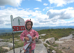
Mount Hereford is popular with hikers. The mountain wilderness is crisscrossed by the twelve-kilometre Neil Tillotson Hiking Trail, which ranges in difficulty from intermediate to advanced. Forests are mixed at the lower levels, but change to conifers and boreal forest on the way to the summit. A number of streams descend to the valleys below, and Donat Falls is a highlight of any hike.
 Mount Hereford is also known as an excellent site for bird-watching. Ornithologists may discover no fewer than fifteen bird species on the mountain, including warblers, juncos, scarlet tanagers, and others.
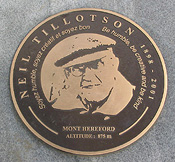
The summit of the mountain is dominated by granite outcrops. A platform features markers identifying surrounding peaks. An interpretive plaque nearby commemorates Neil Tillotson (1898-2001), who is described as “an inventor, entrepreneur and astute businessman” who “traveled through three centuries without ever putting down his walking stick.”
 Born in East Hereford in 1898 and raised in nearby Beecher Falls, Vermont, in 1931 Tillotson invented the latex balloon and eventually founded what would one day be known as the Tillotson Corporation. In honour of Tillotson’s 100th birthday, friend and associate Sam Owen built the “Centennial Road” to the summit. Today, this seasonal gravel road is open free of charge to motorists.