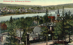
 The towns hug the river bank along the St. Francis. It almost doesn't matter what direction one takes to come to this once bustling railroad community -- the view from the hills as the traveller approaches Richmond or Melbourne is spectactular.
The river, infamous for its stretches of hidden ledge, whirlpools and eddies, has tiny hidden beaches, islands where placid water flows silently and even a small cottage-country near Greenlay. But anyone setting off for the annual county fair here could find history hidden in the bends, swift water and placid bays of this river that seperates Richmond and Melbourne.
Near the towns, the remains of what must have been one of the longest covered bridges, (actually only the stone walls on each bank are still visible) linked the growing towns. Elegant homes graced both banks along this stretch where the best highway was on the river itself in spite of the dangers. Legend tells the tale of the demise of this bridge when an ice jam and a stiff breeze carried it away. Emergency transport took the form of a barge-type raft, frustratingly slow. The contraption was poled across the waters, stabilized with an assembly of ropes that served as a guide as well.
Ancestors in this reporter's family, known for their fast horses and sadly lacking patience, often would whip up their horse to Greenlay, about seven miles upriver, cross the bridge to Windsor and, with a fast horse heading in the general direction of home, arrive back on the Richmond side before one barge-load was tied up.
Then the railroad came to town. Shunting yards were begun, expanded and soon filled, as the small shunt engine hurried up and down the tracks building trains that would travel to Montreal, Quebec, Boston and points in-between. The rails converged on a station that handled passengers and freight from every corner of the globe.
Here also was a "round house," a building with a circular track inside and small "stalls" where engines could be repaired.
"We had six passenger trains a day coming in. You could order fresh sea food for dinner in the morning and serve it that evening," recalled Cliff Gunter, former owner of the Grand Central Hotel.
"Dining rooms were famous here. With so many passengers coming and going all day long, some with a couple of hours to wait, hotel kitchens were wise to earn a fine reputation," he added as we talked about the good old days.
Travellers approaching from the north are following a well-trodden trail that once was a stagecoach road, known as the Craig Road. Of course, roadways have changed over the years, hills trimmed, gullies filled and curves straightened. But just outside of town, the old road bed is still visible and anyone passing can take a moment to imagine the sound of a lumbering "diligence," horses' hooves muddled on the sandy track, harness jangling and the leather straps that supported the swaying coach squeaking as only leather can squeak.
Further downriver, the site of an Indigenous village is still clearly visible. The falls, near Ulverton, about a two or three foot drop, still roar gently, white water rushing away from their base. Another legend tells of the first settlers, arriving by raft and flat-bottomed boat at the Indigenous village, would "shoot" the rapids on this wiley river, and not a one on board able to swim.
There are still photos of men holding the catch of that day, sometimes a river sturgeon, (locally referred to as a "muskilunge"), one hand in the gills, with the monster's tail curling on the ground. "Those fish would be five to six feet long," one old-timer told this reporter, recalling one particularly large beast caught by his father. "That fish would be cleaned, sliced and salted away for the winter. And, my!
it was good. Don't see those anymore."
Coming over the hills from Waterloo on Route 243, travellers would do well to slow down a bit and enjoy the panorama that unfolds as they approach the final descent into Melbourne. Between Racine and Melbourne, the valleys and layers of hills and mountains seem to go on for a hundred miles. Sometimes you can catch a glimpse of Mt. Orford if one glances in the rear-view mirror. Or straight ahead, the Danville Pinnacle rears up on the distant landscape.
Tales of copper mines and rustlers' hideaways abound there and perhaps, at the fair, someone will come along who can recount the old tales and legends of this mysterious, peaked mountain jutting up higher than the hills around it.
The fair itself sits squarely on an ancient lake bed. Fertile, flat land, lying between the mountains the traveller has just travelled through, here, right on the fair site, we could admire acres of feed corn, sturdy farmsteads and grazing cattle.
Deer abound here, so a watchful eye is recommended. They feed in small herds near the woods and tall brush and can startle an inattentive traveller if they suddenly appear on a road or trail.
Even on the fairgrounds, the hills and small mountains are not far away. A walk to the back of the furthest parking area takes one to the foot of a spruce and balsam cliff where the noise of traffic and the trappings of a county fair are only a distant memory. A trip to any county fair, given their age, always holds the promise of a trip back into the history of the area being visited. All it takes is a bit of time, a few facts and a good imagination.