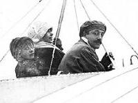
 Aviation pioneer Jacques de Lesseps, or the Comte de Lesseps, as he is often known, was the eldest son of Ferdinand de Lesseps, the French diplomat who was behind the Suez Canal.
Born in 1883, from an early age, de Lesseps developed a keen interest in aviation. In 1909, he enrolled in flying lessons at the Louis Blériot flying school in Bourget, France. He received his pilot’s license the following year. During the First World War, de Lesseps served on the front lines as a bomber and reconnaissance pilot. He also defended Paris against raiding German Zeppelins. For his services during the war, de Lesseps received the Croix de Guerre and the Légion d’honneur from the government of France and the Distinguished Service Medal from the government of the United States.
Following the war, de Lesseps went to work for the Compagnie Aérienne Française (CAF), which specialized in the emerging field of aerial photography. In 1926, the CAF was hired by Quebec’s Ministry of Forests to aerially map the forests of the Gaspé Peninsula. A squabble over jurisdiction (and the hiring of pilots who were not British subjects) ensued between the governments of Quebec and Canada, and the result was the formation of a new company, the Compagnie aérienne Française-Canadienne (CAFC).
De Lesseps became technical director of the new company, which specialized in the production of aerial photographs for the purpose of mapmaking. He was given the task of photographing the Gaspé from the air for Quebec’s Ministry of Forests. Aerial photography was at that time proving to be the ideal method for mapping terrain and forests in regions with difficult access, such as the Gaspé and, elsewhere in Canada, the Rocky Mountains.
In 1926 and 1927, de Lesseps photographed the Gaspé from his Schreck FBA-21 and FBA-17 G-CAFO airplanes, working out of a small air base in the town of Gaspé, with a secondary base at Val-Brillant.
Over a period of less than two years, de Lesseps photographed, often from very low altitudes, over 80,000 square kilometers of territory in the Gaspé. He was the first person to see this part of the world from the air. Writing to one of his friends at the time, he said “you cannot imagine the magnificent and moving view that we have from the skies over the Gaspé… This wondrous sight affords us a contrast in the colours of the vast peninsula and the sea around it…”In October 1927, Jacques de Lesseps and his mechanic, Theodor Chichenko, disappeared on an exploratory flight over the Gulf of the St. Lawrence. The wrecked plane was soon found, but de Lesseps’ body only turned up several weeks later in Newfoundland. The body of the mechanic was never found.
Jacques de Lesseps’ funeral took place in the town of Gaspé on December 14, 1927. In 1932, the town erected a monument in his honour.
In all, the Compagnie aérienne Française-Canadienne produced 1,100 aerial photographs between 1926 and 1928. The majority of these images, which were of extremely high quality, were of the Gaspé Peninsula, though some were of Montreal, Quebec City and surrounding areas. These photographs constitute the very first aerial photographs of Quebec. A number of them were reproduced in postcard format and widely distributed in the 1930s.
Sources:
http://www.banq.qc.ca/histoire_quebec/branche_sur_notre_histoire/photographies_aeriennes.jsp
http://grandquebec.com/gens-du-pays/jacques-lesseps/