 The border separating Quebec’s Eastern Townships from the United States was determined by the terms of the Quebec Act in 1774. At that time, both Canada and the American colonies to the south were dependencies of Great Britain. The border was established – on paper at least -- at 45 degrees north latitude.
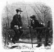
A team of surveyors had been sent out in 1772 to mark off the 45 th parallel. But for some reason, team leader John Collins made serious errors in his calculations. According to local folklore, he and his men drank too much potato whiskey while on the job. The joke is still sometimes told that Stanstead derives its name from the words “stand steady,” which the inebriated surveyors are said to have exhorted one another as they tried to steady their instruments. Folklore or not, the “parallel” the men established was in fact a crooked line that zigzagged across the wilderness. What was worse -- at least from a Canadian perspective -- was that the line zigzagged most of its way well to the north of the 45th parallel. In other words, Canada was losing territory.
 For years, confusion reigned as to where the border was. Before about 1800, there were few settlers in the Eastern Townships, so the issue rarely arose. However, as more people arrived and the region was opened up, disputes began to occur. Some people contended that the border was where Collins had placed it; others said that it was further south, where the Quebec Act had intended it. Some built homes in what they thought was one country, only to find out later that they were actually in another. At Lake Champlain, the Americans even built a fort (sometimes called “ Fort Blunder”) nearly a mile north of the 45th parallel.
In 1842, the United States and Great Britain signed the Webster-Ashburton Treaty, which left the crooked border pretty much where the surveyors had placed it. “ Fort Blunder” remained in U.S. territory, border villages like Derby Line remained American, and many Canadians felt cheated by the British negotiators who were supposedly representing their interests.
To this day, many people still believe that the border separating the Eastern Townships from the northern states is the 45th parallel.