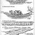
 The first settlers found no roads. They came to a land of virgin forest. They had to blaze their own trails, and find their way around swamps and over streams. They travelled in winter from New England, because snowshoes and a laden sled required a narrower path than an ox cart, and because they could save time by travelling over frozen lakes and rivers. Those coming from Quebec City or Missisquoi Bay often brought laden ox carts. When they arrived at a swamp, they had to throw logs across the path chosen, then cover it with branches and mud so the oxen could cross. The road had to be firm because any ox that got off the "corduroy road," as it was called, would sink into the bog. The pioneers blazed through the forest by cutting notches in trees with a hatchet. This way, others could follow, and they, themselves, could find their way back for families and supplies.
For many years, roads in the Eastern Townships were little more than bumpy, muddy tracks, particularly during rainy periods. Travelling any great distance by horse and wagon could take days, even weeks. During winter, frozen roads were far easier to travel on.
The Old Magog Road:
The Old Magog Road was only a track when first opened in 1794, becoming one of the routes settlers took into the Townships from the United States. They came by way of Philipsburg on Lake Champlain. From there, they followed the rough track to Dunham, where they joined the Old Magog Road and continued to Nelsonville (Cowansville), Gilman's Corner, Calls Mills, and Brome Village. After Brome Village, the road dropped down a steep slope into Bolton Pass near Sally's Pond and on through the pass to the Missisquoi River Valley. From there, it continued over the ridge to drop down once more to the shores of Lake Memphremagog at Knowlton's Landing.
Settlers going to Georgeville on the other side of the lake during winter had to cross the lake on the ice. During summer, they took Copp's Ferry. Until 1820, the Old Magog Road was not considered passable for wheeled vehicles. In 1826, an effort was made to improve it. In 1830, a government grant was arranged and the road was greatly improved so that wagons could pass.
The Craig and Gosford Roads:
Sir James Henry Craig, veteran of the Napoleonic Wars and the American Revolution, was Governor of the British North American colonies. He saw two advantages in building a road from Levis to Richmond. First, it would carry British settlers into the Eastern Townships, offsetting the influx of Americans from New England. Secondly, it could be used to carry farm produce to Quebec City from the growing number of farms in the Townships. Earlier, in 1806, Craig had his own soldiers build a road from Richmond to Danville, and now it was extended to Levis.
By 1811, stage coach service was installed between Quebec City and Boston. For many years, it only functioned regularly in the winter months when frozen roads and streams made travel possible.
In preparing for defense in the War of 1812 with the United States, Craig's soldiers destroyed all the bridges on the Craig Road and blocked off the road in several places. However, by 1829, the danger of invasion had passed, and the Craig Road was reported to be in fair condition once again. A new stretch of road named after Governor Gosford went through the centre of Inverness Township to Maple Grove in Ireland Township. It joined the section called Dudswell Road. After 1840, the Craig Road regained its due care and respect.
Other Roads:
In 1836, a road ran between Montreal and Sherbrooke via Shefford, and another from Sherbrooke to Levis. A bridge over the St. Francis had been completed near Sherbrooke, forming an important early link in the chain.