 The southeast corner of the province of Quebec is home to the region known as the Eastern Townships. The region is famous across Canada and internationally for its scenic beauty and history.
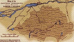
The term "Eastern Townships" is an old one. Geographically it refers to that vast region of Quebec that is bounded on the west by the old seigneurial lands along the Richelieu and Yamaska Rivers; on the south by the Vermont border; on the southeast by the New Hampshire and Maine borders, and on the east and north by the old seigneurial lands along the Chaudière and St. Lawrence Rivers. Beginning with a Proclamation in 1792 by Alured Clarke, Lieutenant-Governor of Lower Canada (Quebec), this vast territory was subdivided into townships. The process would take years, and eventually resulted in the creation of 95 townships.*
By the early 1800s, the region began to be known collectively as "the Eastern Townships."** The reason for this designation remains a subject of discussion. The prevailing theory is that the term distinguishes the region from the comparable and older "western" townships of Upper Canada (Ontario). However, the term may equally have been adopted to distinguish the region from the townships west of the Richelieu River and those along the Ottawa River.
The term "Eastern Townships" remains in common use. Its first French-language equivalent was "Les Townships de l'Est," but beginning in 1858, "Les Cantons de l'Est" came into popular usage. The term "Estrie" was coined in the 1940s, and officially adopted in 1981 with the creation of an administrative region by that name. "Estrie," however, corresponds to only a fraction of the historic Eastern Townships, and the term Cantons de l'Est is preferred by many over the bureaucratic and historically irrelevant "Estrie."
*This figure does not include St. Armand, along the Vermont border east of Lake Champlain, which was technically part of the seigneurial lands, and never classified as a township. St. Armand was, however, settled by Loyalists, and divided into lots similar to those of the Eastern Townships. It is generally considered part of the Eastern Townships. It also includes all of the later townships created on the east side of Lake Megantic and the Arnold and Chaudière Rivers, between the Maine border and the confluence of the Chaudière and du Loup (Linière) Rivers. The last townships to be proclaimed were Louise and Risborough, in 1920.
**The term "Eastern Townships of Canada" was apparently first used on a surveyor's map in1796.