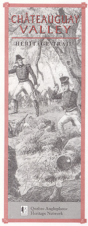
The Châteauguay Valley Heritage Trail leads to rural communities, pioneer townsites and landmarks in Southwest Quebec.
British colonists settled this region in the early 1800s, but the Châteauguay Valley’s colonial history starts in New France. In 1729, King Louis XV gave Charles and Claude de Beauharnois title to a swath of woodland south of the St. Lawrence; it was mostly uninhabited when England acquired the colony in 1763. London merchant Alexander Ellice bought the Beauharnois seigneury in 1795.
After making Quebec into Upper and Lower Canada in 1791, Britain cut the land between the seigneury and the U.S. border into townships. A few American squatters began to farm. Then a large wave of settlers from Scotland and Ireland came to the Châteauguay in the 1820s and 1830s.
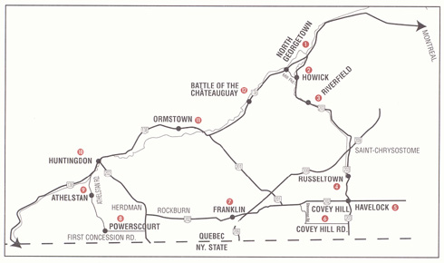
This Trail follows the English River (Rivière des anglais) from Howick south along Rte. 203, veers west onto Rte. 202 near the U.S. border and north onto Rte. 138 to form a loop.
GETTING THERE
From Montreal, head toward Châteauguay across the Mercier Bridge and continue west along Rte. 138. From the Eastern Townships, follow Autoroute 10 toward Montreal. Take Autoroute 30 west and exit southbound onto Rte. 138.
Other Resources
Travelers may wish to get a copy of the tour guide, Le circuit du paysan. It lists restaurants and services along the Heritage Trail. Visit a tourist bureau in the region or call (800) 378-7648.
NORTH GEORGETOWN
The Georgetown Presbyterian Church, near the junction of Rte. 138 and Mill Road, is a relic of an old Scottish settlement. The adjacent cemetery has been used since 1806. A wooden church was erected here in 1823. The current structure dates to 1851.
Nearby, Turcot Bridge spans the Châteauguay River with a distinctive arch. It was built in 1889 so that area farmers could move grain to Beauharnois port.
HOWICK
Alexander Ellice ordered a grist mill built here on the English River in 1803. Dubbed George’s Mill after one of the seigneur’s sons, the millsite grew into the settlement later named for British baron Charles Grey (also titled Viscount Howick), who served as Britain’s prime minister in the 1830s.
Howick Model School, built in 1915, now serves as the town hall. Its original floor plan and many inside details are intact. As you leave the village to join Rte. 203, note the splendid United Church, built in 1927.
RIVERFIELD
This crossroads at the junction of Rte. 203 and Rang des Écossais (formerly the Scotch Concession Road) was once called English River. Presbyterians built the neo-gothic stone church here in 1869. The cemetery dates to 1828.
 RUSSELTOWN
Just south of St-Chrysostome (formerly Edwardstown) on Rte. 203 the trace of a vanished pioneer village stands. Russeltown Church was built in 1829 for Methodists and Congregationalists. James Duncan built the first mill at Edwardstown in 1820 and is buried here.
HAVELOCK
Loyalists began planting apple trees on the slopes of nearby Covey Hill around 1800. Apples supplied pioneers with many useful products, including syrup, pectin and cider vinegar. Family orchards gave rise to commercial orchards after 1850.
At the junction of routes 203 and 202, Havelock lies in the middle of Southwest Quebec’s vast fruit belt.
Havelock takes its name from Maj. Gen Henry Havelock, a Britsh hero of the Crimean War. It was once called Mannagh's Corners after Irish pioneer David Mannagh. Note the fieldstone town hall, an historic monument, built in 1868 by Thomas Sanders.
 COVEY HILL LOOKOUT
(Elevation: 342 metres)
In the foothills of the Adirondack Mountains lies Covey Hill, once called Hemmingford Mountain. It offers a panoramic view of the surrounding countryside.
FRANKLIN
Fine examples of early masonry can be found all along Rte. 202. One fieldstone house stands out: the three-storey Gentle home on the north side of the road between Franklin and Rockburn. Andrew Gentle, a Scottish brewer, came to Franklin from New Jersey via Hemmingford in 1808 and first lived in a small cabin. His son Hiram built the stone house in 1842-43. Its basement walls are said to be four feet thick.
Now drive to the flashing light at Herdman and turn left.
 POWERSCOURT COVERED BRIDGE
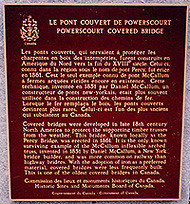
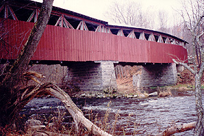
The Percy Bridge on First Concession Rd. is the second-oldest covered bridge in Canada and the only remaining example of an Inflexible Arched Truss design, patented by U.S. carpenter Daniel McCallum. Built in 1861 by Robert Graham, a blacksmith from Athelstan, it’s classified as an historic monument.
ATHELSTAN
A monument marks the site of Canada’s first butter factory, built in 1873 by farmers Dan Boyce and John Dineen. Cheese and butter factories sprang up at Athelstan and at Helena settlement on Trout River in 1881. They were the first in Canada to drive churns with horse power. Though the Athelstan creamery failed financially, its model for the commercial dairy smoothed the way for other processors in Quebec.
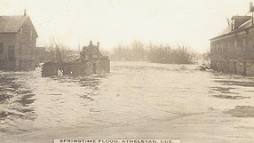 Athelstan was also the birthplace of Hugh Graham, founder of the Montreal Star newspaper. The Presbyterian Church dates to 1877.
HUNTINGDON
(Population: 2,635)
A trail cleared between the St. Lawrence River and the future site of Huntingdon in 1821 attracted millers, wheelwrights, blacksmiths and shoemakers. Cross the concrete bridge to see traces of an extensive water-powered milling complex started in 1832 by English immigrant William Bowron. A plaque gives details on its history. Food exports jumped during the U.S. civil war, driving demand for farm machinery. Daniel Boyd & Co. made hay mowers, horse-powered threshers and a line of tools. In 1863 Robert Sellars, a 22-year-old Scotsman working at the Toronto Globe, moved to Huntingdon to start The Gleaner, a weekly paper still serving valley communities.
The first railroad arrived in 1883; the first phone in 1884. The Huntingdon Organ Co. built a factory in 1886. A branch of the Eastern Townships Bank opened in 1887, followed by the Huntingdon County Bank. Visitors may wish to tour the town on foot. Ten information panels have been erected at various sites.
For walking tour details, call: (450) 264-5389.
 ORMSTOWN
(Population: 1,620)
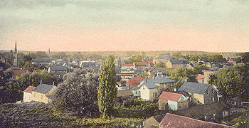
Ormstown was once the brick-making capital of Quebec. During peak years 1874-1925, clay pits and brickyards run by the Lockerby, McGill, and Baird families employed hundreds of men. This heritage lives on in the many brick homes and public buildings throughout the Valley. Several examples exist in Ormstown, along Lambton, Church and Bridge streets. The old fire hall, now Town Hall, dates to 1901.
Since 1910 the Ormstown Exhibition has played a core role in the social and economic life of the Châteauguay Valley. The June fair boasts one of the leading horse shows in Canada.
Ormstown Fair Telephone: (450) 825-2512
Website: www.ormstownfair.com
BATTLE OF THE CHÂTEAUGUAY
National Historic Site
Allan’s Corners was named after the family who operated a store and post office here in the mid 1800s. In a nearby clearing during the War of 1812-14, a volunteer force of 800 mostly French-Canadian soldiers turned back 5,000 U.S. troops marching on Montreal.
The battle on October 26, 1813 united local Scottish militia, Mohawk Indians, a few British regulars and the celebrated Voltigeurs regiment under Lt-Col. Charles-Michel de Salaberry to form the “first ever truly Canadian army” according to one historian. Parks Canada operates a museum and interpretation centre here from mid-May through October.
Visit the centre online at www.parcscanada.gc.ca/chateauguay
Telephone: (450) 829-2003
The Heritage Trail series is presented by the Quebec Anglophone Heritage Network, funded jointly by the Department of Canadian Heritage and Economic Development Canada. Space constraints preclude mention of all possible sites. Many thanks to Robert McGee of the Châteauguay Valley Historical Society. For more information call the QAHN office at (819) 564-9595 or toll free within Quebec at 1-877-964-0409.![]()
![]()