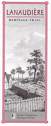
The Lanaudière Heritage Trail leads to heritage sites and historic settlements in Quebec’s Lanaudière region, between the foothills of the Laurentians and the lowlands of the St. Lawrence River.
Along the river lie the ancient seigneuries of Repentigny, Lavaltrie and Saint Sulpice, where fledgling colonies in the heartland of New France gave rise to bustling towns on one of the continent’s greatest inland shipping routes.
During the 1820s and 1830s, the old French towns of Berthier and L’Assomption were outposts of European civilization. They were well known to Irish and Scottish immigrants making their way to the new townships of Brandon, Kilkenny, Rawdon and Kildare.
Sandy, rocky Laurentian soil made farming difficult. Although most raised crops and some livestock, homesteaders in the burgeoning settlements depended for their livelihood on sales of potash and lumber.
Sawmills would multiply along the Assomption, Bayonne and Ouareau rivers in the 1800s, with villages growing up around the best millsites. In 1844, not less than nine sawmills were reported operating in Rawdon alone.
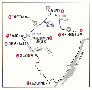
This Trail description is presented in a clockwise direction, starting at L’Assomption and ending at Berthierville. However, the route may be started at any point and driven in either direction.
 HOW TO GET THERE
From Montreal, take Autoroute 40 east past Repentigny and following the signs for L’Assomption. From here, the Trail leads north along Route 341. Travelers coming from the direction of Quebec City or Trois Rivières may follow Autoroute 40 west to Berthierville. From the south shore, take the ferry from Sorel to Berthierville past the Berthier Islands, part of the Lac St-Pierre archipelago, a United Nations-designated biosphere reserve.
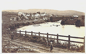
L’ASSOMPTION
Begin your tour of the Lanaudière in the heart of L’Assomption Parish, once part of a vast seigneury run by Catholic priests from Montreal’s Seminary of Saint-Sulpice. The historic quarter on the banks of the L’Assomption River is a veritable treasury of early- and mid-19th century structures, recalling L’Assomption’s early vocation as a centre of learning, worship, trade and government.
A walking-tour guide offered by the Centre regional d’archives de Lanaudière (270 Blvd. l’Ange-Gardien) features 30 local heritage sites, including one of North America’s oldest courthouse buildings (1811) and the Collège de L’Assomption (1844), home of the region’s first private Catholic school.
 In 1724. French curé Pierre LeSueur led the first group of European settlers to the present townsite, located strategically on a traditional portage route well-known to coureurs-des-bois and Algonquin trappers. They were followed in the 1760s by a number of Acadian families deported by the British from their homelands in Nova Scotia. Scottish merchant George McBeath, a shareholder in the famous North West Company and member of Lower Canada’s legislative assembly, opened a trading post in L’Assomption in 1785.
At the height of the fur trade, local finger weavers of Acadian descent gained fame as creators of the acclaimed L’Assomption Sash, a colourful fringed belt worn by Métis trappers.
Centre regional d¹archives de Lanaudière.
270 Blvd. L’Ange-Gardien
l’Assomption, Tel: (450) 589-0233
SAINT-JACQUES
The general store at the corner of chemin Gaudet and Route 341 marks the northern reaches of the old Saint-Sulpice seigneury and the beginning of historic Rawdon Township. Note the change in the way farms are arranged along the highway. Whereas the old Acadian dwellings to the south lie close to the road, British farmers built their homesteads much farther back.
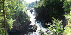
DORWIN FALLS
A spectacular lookout above these 60-foot-high waterfalls just south of the town of Rawdon attracts thousands of tourists each year. The site is named for J. Dorwin, a Montreal-based merchant-trader and business promoter who helped finance early industrial growth in Lanaudière.
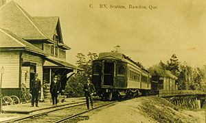
Dorwin owned sawmills on the Ouraeau River and was the first president of the shortlived Industry Village and Rawdon Railway (1852-1858) that linked St. Ligouri with present-day Joliette. The first train came to Rawdon in 1910.
RAWDON
This former lumber town is the cultural and economic heart of Lanaudière’s remaining English-speaking population. Named for a British veteran of the American Revolution, Rawdon grew up in the early 19th century on a plateau between the Ouraeau and Red rivers, flanked by a series of outstanding waterfalls. Townsfolk are proud the community’s multiethnic ancestry, which includes British, French, Slavic and Hungarian influences.
The first settler in the Rawdon area was Philemon Dugas, believed to have come from Boston in 1815. Waves of Irish, Scottish, English, and French settlers followed in the 1820s and 1830s. Descendants of many pioneer families still live in the area.
 Buildings along Church and Metcalfe streets and 3rd and 4th avenues make up Rawdon’s unofficial historical district. Christ Church (1857), a masterpiece of Quebec stonemasonry, is a designated historic site. Rawdon’s former military barracks is reputedly the oldest building in town. Standing at 3567 Church Street, the circa-1820s structure now houses the Bouleaux Argentés retirement home. A few neglected headstones mark settlers’ graves at the rear of the property.
Beginning in the 1930s, Rawdon attracted a number of immigrants from Poland, Hungary, Ukraine, Czechoslovakia, and Russia. One of the town’s more striking buildings is the St-Seraphin Eastern Orthodox Church, a Byzantine-style domed chapel at the corner of Woodard St. and 15th Avenue.
Rawdon’s Irish Catholics established two internationally renowned schools. Ste-Anne’s Convent on Lake Morgan Road, which dates to Confederation, was an early promoter of bilingual education for girls; St-Anselme’s Academy (3713 Queen St.) was founded in 1910 as an English boys’ high school. It has operated in French since 1948 under the name Collège Champagneur.
Billed as a vacation spot in the 1930s, growth surged in Rawdon after World War II. Some nearby farm settlements like Gratten Lake became colonies of weekend residents and summer cottagers. Other communities developed along the Rawdon and Pontbriand lakes, created in the 1910s by damming the Red and Oureau rivers.
Rawdon Historical Society (450) 834-2108
MONTCALM CORNERS
The oldest settlement in historic Rawdon Township sits a few kilometres east of present-day Rawdon on a bend in the Red River where Philemon Dugas erected his lumber mill in 1815. At one time the hamlet was served by a railroad station and rivaled nearby Saint-Ligouri in size. Follow Route 348 out of Rawdon, turn right on chemin Forest, an old settler road, and drive as far as chemin Wilfrid. Rawdon Township¹s original school and church were situated at this crossroads. To reach Montcalm Corners, turn left onto Wilfrid, then right onto the 5th Range Road (Rang 5).
Return to Route 348 to continue your tour of the Trail region.
RADSTOCK (Ste-Marceline-de-Kildare)
Population: 1,200
Much of the farmland round this hamlet was originally granted to Irish-born soldiers who’d helped defend Canada against American invasion during the War of 1812-14. The settlement scheme pushed by the township’s first colonial land agent, Major Beauchamp Colclough, never came to be.
The “Town of Kildare” as Colclough called it, was to have been a colony of retired British military pensioners where old warriors could live out their days trading battle stories and reminiscing about their Irish homeland. Property lots were assigned to the major’s underlings in the 103rd Infantry Regiment; streets were planned; and land was set aside for a school and prison. But Colclough went bankrupt in 1835 and interest in the project waned.
In 1843, Anglicans built a square-log church on the Kildare Range (Route 343). The church was moved to Rawdon many years ago, but Saint-John’s Anglican Cemetery can still be seen.
Before the exodus of English-speaking families from Kildare started in the 1880s, the hamlet was called Radstock, the name given to the post office established here in 1865.
RAMSEY PIONEER CEMETERY
(Near Saint-Félix-de-Valois)
The Kildare Range (Route 348), which passes through the village of Ste. Melanie in front of a magnificent stone church (1869), was first settled by Irish Protestants. The farming village of Ramsey grew up at the junction of Route 348 and the 2nd Range Road. All Saint’s Anglican Church bears quiet testament to British settlers’ brief sojourn in the district. Services are still given in the brick church twice a year by the Anglican ministry in Rawdon. The well-kept churchyard cemetery is a roster of English-speaking pioneer families.
Route 345, which passes through Saint-Félix before turning southward along the Bayonne River, follows the route of an original pioneer trail.
BERTHIERVILLE
This old town near the mouth of the Bayonne River is studded with elegant dwellings of 19th century notables, including offspring and associates of Scottish-born seigneur James Cuthbert.
 A soldier who had served as General Wolfe’s aide-de-camp during the Battle of the Plains of Abraham (1759), Cuthbert acquired the sparsely populated Berthier seigneury in 1765, expanding his landholdings considerably while holding powerful posts in the British colonial government. Title passed to his son, James Jr. and on to his grandson, Edward, before Quebec’s seigneurial system was abolished in 1854. Another son, Ross, became lord of the neigbouring seigneuries of Autray and Lanoraie.
During the busy settlement era of in the 1820s, 30s and 40s, Berthierville was a gateway for British immigrants bound for townships in the Laurentian foothills to the north. The village prospered as a commercial outlet for manufactured goods destined for new settlements in the hinterlands, giving rise to a sizeable English-speaking minority.
Today Berthierville is probably best known as the birthplace of Québécois racing car sensation Gilles Villeneuve.
CUTHBERT CHAPEL
The oldest Presbyterian sanctuary in Quebec can be found at the junction of routes 138 and 158. Cuthbert built the chapel to honor the memory of his wife in 1786. It has been protected as a historical monument since 1958, and currently hosts a very convenient visitor’s bureau, open from May to October. Travelers will find an informative guide here to over 20 other heritage buildings, including the original Berthier Grammar School (1880-1917) at 562 rue Montcalm and the last of the Cuthbert manor houses in Berthierville at 710 rue Frontenac.
The house built in 1821 by Lanoraie seigneur Ross Cuthbert to accommodate servants stands west of Berthierville on Route 138 (701 Grande-Côte Est.) It was occupied until the 1970s by the last descendant of the Cuthbert family to live in the area, Margaret Bostwick.
Corporation du patrimoine de Berthier
(450) 836-8158
This guide is presented by the Quebec Anglophone Heritage Network. The Heritage Trail series is made possible by grants from the Department of Canadian Heritage and Economic Development Canada. Space constraints preclude mention of all possible sites. Thanks to Beverly Prud’homme of the Rawdon Historical Society. For more information call the QAHN office at (819) 564-9595; toll free within Quebec at 1 (877) 964-0409.
![]()
![]()