Quebec’s upper St. Francis River cuts through dense woodland in mountainous backcountry, far from the treeless north Scottish coast. Yet the lilt of Gaelic once rang out in rock-strewn fields and crofters’ cabins.
Farm families in Scotland’s Highland region faced starvation in the 1830s. Landowners hoping to profit from wool sales to industry cleared tenants from cropland to make way for sheep. Farmers were squeezed into small beach-front lots called crofts, where they were put to use gathering and processing seaweed for soap factories. Crofters came to depend on potatoes for food. When crop failures turned them into paupers, landlords forced them to emigrate.
Sixty families boarded the ship Energy in Stornoway on the Isle of Lewis in 1838, bound for wilderness homesteads in Quebec’s Eastern Townships. The London-based British American Land Company owned rights to most crown land in the district and hired the settlers to build roads, bridges and mills.
With much of the upper St. Francis district unsuitable for grain crops, immigrants turned to logging. Joined by French-Canadian and Irish Catholic colonists, the Highlanders built a way of life based on forestry and small-scale farming. By the late 1800s some 3,000 Gaelic-speakers peopled the region.
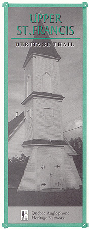
This Heritage Trail leads through one of Quebec’s oldest lumbering districts and a cradle of Canada’s pulp-and-paper industry. Although most descendants of the Highland pioneers have moved away, their memory is admirably preserved in churches and graveyards and by local heritage groups such as the Ceilidh Society of Scotstown.
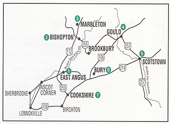 HOW TO GET THERE
From Sherbrooke follow Route 112 to East Angus. A scenic route begins at Lennoxville, 32 kilometres from the Vermont-Quebec border on Route 143. Drive east on Route 108, past Bishop’s University, and turn left on Spring Road, leading to the village of Ascot Corner. Chemin Rivière from Ascot Corner follows the St. Francis River to East Angus along a stretch of the historic Gosford Road.
EAST ANGUS
(Pop. 3,604)
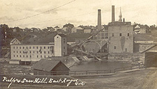
A busy paper-mill town, East Angus was built next to rapids on the upper St. Francis, just below its juncture with the Eaton River. The town’s history dates to 1881, when Scottish-born entrepreneur William Angus chose the site in Westbury Township to build a paper factory and sawmill. The modern-day paper plant employs 500 people.
Angus was a paper-making pioneer. Before coming to Westbury Falls, he’d launched Canada’s first chemical pulp-and-paper plant downriver at Windsor Mills. The division between workers and managers in East Angus fell along linguistic lines for many decades. English-speaking bosses occupied big houses on the south bank of the St. Francis, while mainly French workers settled in poorer neighborhoods to the north. Today, most of the few remaining English-speaking families live on farms outside town.
 Veer right onto Warner Street after crossing the bridge for a quick tour through the old English quarter. The wooden Emmanuel United Church is a prominent landmark. The English high school on Maple Street has been converted into a community centre. There are two pioneer cemeteries nearby: one on Coates Road and the other in the hamlet of Westbury.
BISHOPTON
(Pop. 450)
This village features a fine collection of well-preserved 19th-century wood homes and churches, most dating to the golden age of Townships railways.
Nestled between the north bank of the St. Francis River and Mirror Lake, the village was founded by Capt. John Bishop, veteran of the American Revolution, who settled in Dudswell Township in 1800. Though English-speaking residents form a small minority today, their influence on Bishopton’s early development shows in the village’s New England and Victorian-style architecture.
A walking-tour guide to historic sites, available from the Maison de la culture in nearby Marbleton, identifies two dozen buildings, including several Bishop family homes on rue Bishop, the old Andrews general store at 84 Main Street, and a number of pioneer cemeteries.
MARBLETON
(Pop. 500)
A few kilometres north of Route 112 lies Marbleton, a lime-quarry town on the shores of Silver Lake and Adolphe Lake. Louis-Émile Beauregard’s fascinating collection of miniature wood carvings is a popular visitor attraction, located at the Maison de la culture. A native of Dudswell Township, Beauregard was a self-taught master folk carver who created a series of intricate scale models of rural life out of pine wood.
 Maison de la culture
900, rue du Lac: (819) 887-6093
GOULD
(Pop. 75)
Scottish immigrants settled in the vicinity of this hamlet on the Salmon River in the 1830s when the British American Land Company (BALC) first opened Lingwick Township to colonists. In addition to clearing land for their own homesteads, Isle of Lewis settlers built the road (Route 108) from Gould to Bury, another BALC colony.
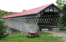
The McVetty-McKenny covered bridge, which spans the river a few kilometres north of here on Route 257 is the longest covered bridge in the Townships. Many early settlements that sprang up around Gould have since passed into memory: North Hill, Galson and Red Mountain, to name a few.
 Today’s visitors find a lively mix of Québécois and Scottish fare at Gould’s historic general store (1845), now operating as a small inn and restaurant. The old store once belonged to James Ross, a former boat captain who immigrated to Quebec in 1829 and who was Gould’s first mayor. Chalmers United Church next door was erected by a local Presbyterian community in 1892 using bricks from dismantled homes at BALC’s abandoned colony of Victoria Village, nine miles upriver.
Bagpipes, tartans, traditional dancing and Gaelic-language workshops are on the menu during Gould’s popular Festival of Scottish Traditions, which takes place each autumn. As it leads southeast to Scotstown, the Heritage Trail passes the Lingwick Pioneer Cemetery on Sand Dirt Road (Route 257).
Festival of Scottish Traditions: 1 (888) 305-3526
SCOTSTOWN
(Pop. 700)
Scotstown is named for John Scott, a Glasgow pioneer who led his family to Hampden Township in the 1870s as manager of the Glasgow and Canadian Land and Trust Company. The town grew up around the company sawmill on the Salmon River and retains much of its frontier-like charm.
From Gould, the road into Scotstown (Route 257) leads past St. Paul’s Presbyterian Church, built in 1926, and on to the former millpond.
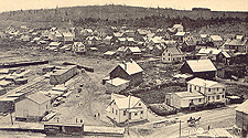 Scotstown served as a commercial hub for lumber camps and farms in the district after the International Railway arrived in 1877. At one time, Scotstown boasted several stores, a harness maker, blacksmith, shoemaker, notary and a doctor. George Sherman built the local hotel in 1884.
A lone brick smokestack towering above the water recalls the town’s heyday as a wood-manufacturing centre: the chimney is a remnant of a factory opened here in 1909 by the Guelph Patent Cask, Veneer and Plywood Company of Michigan.
St. Andrew’s United Church (1885) at 123 Coleman Street was Scotstown’s first Presbyterian church. The old English high school (1924) at 101 Victoria Street West today houses the municipal offices. Members of the local Ceilidh Society celebrate Scottish traditions with a special Robbie Burns dinner in January and a family picnic each July.
Bown Cemetery on Route 214, west of the village, is all that remains of the vanished settlement of Bown’s Mills.
Scotstown Ceilidh Society: (819) 657-4609
BURY
(Pop. 1,230)
This quiet and picturesque village is famous for its ambitious Canada Day parades, considered the largest in Quebec outside of Montreal. Founded in the 1830s as a BALC colony, Bury was a lumber town known as Robinson to the early Scottish pioneers. Although Gaelic is no longer spoken, the settlement’s British heritage is deeply ingrained. The local golf course, once the private playground of Compton County’s prominent Pope family, is one of the oldest in Quebec.
 Memorial Park behind historic Old Town Hall at 569 Main Street is a good place to contemplate the hardships early inhabitants faced building their community in what was an isolated logging village. The striking white clapboard building (1865) is an architectural gem.
A number of heritage buildings adorn Main, Stokes and McIver streets, including the brick Fairview School (1907) at 535-A Main Street, and the old United Church (1868) across the street. St. Paul’s Anglican and St. Raphael Catholic churches are still active. Many generations of Anglophones have been laid to rest in the Protestant cemetery on McIver Street.
COOKSHIRE
(Pop. 1,560)
Until 1836, when the British American Land Company built a bridge over the Eaton River, Cookshire stood at the edge of a wilderness on the region’s eastern frontier. New England pioneers John Cook, John French, Col. J.H. Taylor and Israel Bayley had cleared land on the present town site as early as 1798. Upon Cook’s death, Taylor named the settlement in his honour.
A prominent Eastern Townships financier and politician named John Henry Pope was instrumental in developing Cookshire into a lumber, transportation and farming centre. As Member of Parliament for Compton County, Pope gained notoriety in John A. MacDonald’s cabinet as Canada’s first minister of agriculture. He later served as minister of canals and railways.
Pope is chiefly remembered for raising money to finish building the Canadian Pacific Railway and for securing a railway link for his own riding into the bargain. The family’s gracious Second-Empire style residence at 10 Pope Street dates to 1880 and currently houses a medical clinic.
 Many heritage homes along Pope, Eastview, Principale and Craig streets display architectural features considered rare in Quebec such as recessed second-storey porches. Saint Peter’s Anglican Church (1867) at 30 Principale Ouest is the only stone Protestant church in the area.
Though English speakers account for less than a fifth of the population today, Cookshire Academy (1884) at 95 rue du Parc continues to offer public English-language instruction.
Visitors to Cookshire can admire the John Henry Cook Covered Bridge (1868), located just north of the town on Craig Street (Route 253); and the Trinity United Church (1863), originally a Methodist temple, on the corner of Principale Ouest and Pope. Leaving town westward on Route 108, the Trail passes Compton County’s historic fairgrounds. A complete guide to local heritage sites is available at the town hall.
St-Francis Historical Society: (819) 875-1022
Cookshire Town Hall: (819) 875-3165
This guide is presented by the Quebec Anglophone Heritage Network. The Heritage Trail series is made possible by grants from the Department of Canadian Heritage and Economic Development Canada. Space constraints preclude mention of all possible sites. Thanks to Madeline Irving of the Ceilidh Society of Scotstown, Karin Fisher of the Bury Historical Society and the Société d'histoire et du patrimoine du Haut-Saint-François. For more information call the QAHN office at (819) 564-9595 (toll free within Quebec at 1 (877) 964-0409).![]()
![]()